

OPTIONS DE LIVRAISON LOCALE
La livraison standard est généralement de 3 à 7 jours.La livraison express est généralement de 2 à 4 jours.
GARANTIE DE PRIX
Si vous trouvez un prix moins cher dans les 72 heures qui suivent, nous vous l'égalerons.
Original price was: 249,99 €.224,99 €Current price is: 224,99 €.
You save
La livraison standard est généralement de 3 à 7 jours.La livraison express est généralement de 2 à 4 jours.
Si vous trouvez un prix moins cher dans les 72 heures qui suivent, nous vous l'égalerons.
Bénéficiez d'une remise initiale de 5% sur votre première commande en vous inscrivant sur la communauté SailRACE.
Bénéficiez de l'assistance d'experts officiellement certifiés. Détaillez-nous vos besoins de réaménagement et nous vous aiderons à déterminer la meilleure solution.
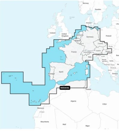
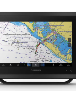
Featuring vibrant colors, a streamlined interface and combined coastal/inland content with a popular Navionics® style color palette, Garmin Navionics+ cartography makes it easy to plot your course with the world’s No. 1 name in marine mapping.
Navigate with our best offshore and inland lake coverage for your Garmin chartplotter.
See it your way. Customize your view with various chart layers and overlay combinations.
With your included one-year subscription, access daily updates via the ActiveCaptain® smart-device app.
Auto Guidance+™ technology lets you navigate with suggested dock-to-dock routings.
Select up to 10 color-shaded target depth ranges to scope out the best fishing spots.
Save money by renewing your subscription — and continue accessing daily updates plus new content downloads.
ALL-IN-ONE MAP SOLUTION FOR GARMIN CHARTPLOTTERS
Access detail-rich mapping of coastal features, lakes, rivers and more. Integrated Garmin and Navionics® content offers coverage for boaters worldwide.
DAILY CHART UPDATES
Charts are constantly being enhanced with new and amended content: Thousands of updates are made every day. The one-year included subscription gives you access to daily chart updates via the ActiveCaptain app.
Combining the best of Garmin and Navionics automatic routing features, built-in Auto Guidance+ technology gives you a suggested dock-to-dock path to follow through channels, inlets, marina entrances and more.
High-resolution depth range shading lets you select up to 10 color-shaded options and view your designated target depths at a glance.
For improved fishing and navigation, up to 1′ contours provide a clear depiction of bottom structure for improved fishing charts and enhanced detail in swamps, canals, harbors, marinas and more.
To give a clear picture of shallow waters to avoid, this feature allows for shading at a user-defined depth.
Community-sourced content provides useful points of interest, such as marinas, anchorages, hazards, businesses and more. Get recommendations from boaters with firsthand experience of the local environment.
This detailed shading feature combines color and shadow to give you an easy-to-interpret, clearer view of bottom structure than contour lines alone.
Downloadable high-resolution satellite imagery provides superior situational awareness.
Crystal-clear aerial and surface photos of ports, marinas, bridges, docks, boat ramps, dams and navigational landmarks provide a better sense of your surroundings above the waterline.
This underwater perspective shows 3D representation of bottom and contours as seen from below the waterline. Interface with sonar data for a customized view.
This view provides a 3D representation of the surrounding area both above and below the waterline.
Adjust your maps to the lake’s current water levels to see if spots are accessible or too shallow to explore.
Les produits suivants appartiennent à la même catégorie que celle-ci :
Garmin


Examens
Il n'y a pas encore de commentaires