


LOCAL DELIVERY OPTIONS
Standard Delivery usually 3-7 days.Express Delivery usually 2-4 days.
PRICE GUARANTEE
If you find a cheaper price in the next 72 hours we will match it.


377,99 € – 566,99 €
You save
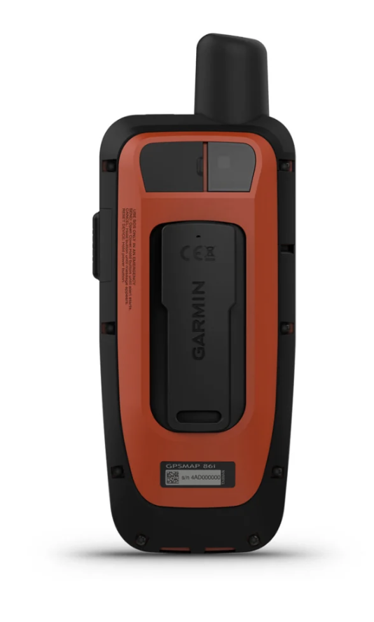
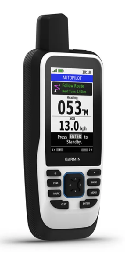
Stay on track with the GPSMAP 86 handheld device. It provides all the outdoor functions of the GPSMAP® 66 series, in addition to navigation functions, such as wireless connectivity in your built-in nautical system.
Standard Delivery usually 3-7 days.Express Delivery usually 2-4 days.
If you find a cheaper price in the next 72 hours we will match it.
Claim your initial 5% discount on your first order by registering on the SailRACE community.
Get support by officially certified experts. Detail us your refitting needs and we will help you determining the best solution.
Stay on track with the GPSMAP 86 handheld device. It provides all the outdoor functions of the GPSMAP® 66 series, in addition to navigation functions, such as wireless connectivity in your built-in nautical system.
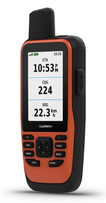
DATA OF THE BOAT
Synchronize it with Garmin plotters and compatible instruments to view the boat’s data in real time directly on the handheld device.
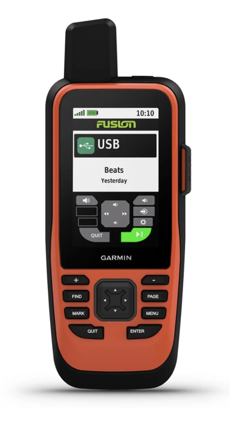
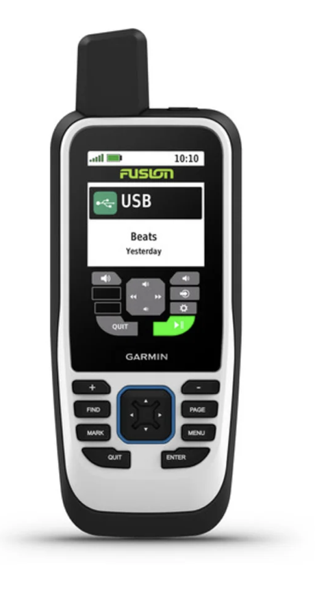
FUSION-LINK AUDIO
Take advantage of a comfortable remote operation of certain Fusion nautical products on board.
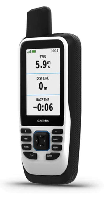
ACCURATE FOLLOW-UP
When you are scrolling, the adjustable GPS filter reduces speed and direction errors in case of waves to get a more accurate tracking.
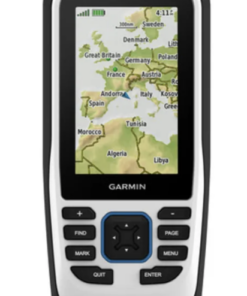
WORLD BASE MAP
Check the world coverage with shaded relief, including the most important oceans, seas, lakes and rivers, in addition to international and political borders, and time zone information.
BLUECHART COVERAGE
BlueChart g3 Adds optional nautical charts, which offer industry-leading coverage, clarity and level of detail with integrated Garmin and Navionics data.
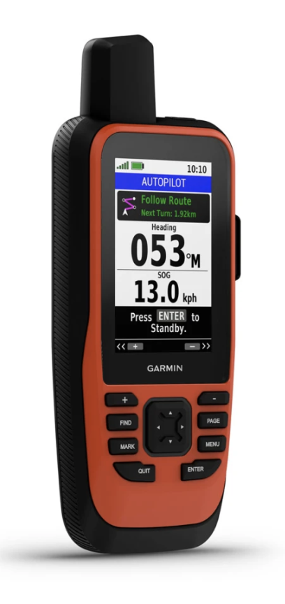
AUTOMATIC PILOT REMOTE CONTROL
Even if you are not on the bridge, you will be able to control the boat. Access the autopilot application to change the course, enable the navigation pattern and follow a route with GPS.
SECONDARY NAVIGATION
Whether you are going to spend the day fishing or on a sailing or motorboat, you will have the peace of mind of taking a reservation navigator with you.
ABC SENSORS
It uses ABC sensors on each route; they include an altimeter to obtain height data, a barometer to monitor weather changes and a three-axis electronic compass.
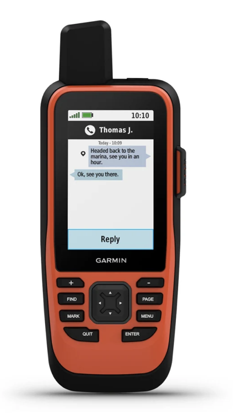
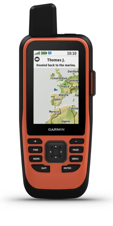
SMART NOTIFICATIONS
Receive smart notifications directly on your GPSMAP 86s handheld device when you link it to your compatible smartphone.
GARMIN EXPLORE APP™
Synchronize GPSMAP 86s with Garmin Explore to access your favorite waypoints, tracks and routes in the cloud.
WIRELESS CONNECTIVITY
The GPSMAP 86s offers Wi-Fi® connectivity, ANT+® technology and Bluetooth® wireless technology to facilitate updates and wireless connections.
LED FLASHLIGHT
The GPSMAP 86s allows you not to have to carry a large equipment, since it has an integrated LED flashlight that can be used as a beacon to indicate your position in case you need help.
BATTERY AUTONOMY
The rechargeable internal lithium battery provides up to 40 hours of operation. in standard mode and up to 200 hours in low-power mode.
| Physical And Performance Characteristics | |
|---|---|
| LENS MATERIAL | chemically strengthened glass |
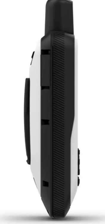
| DIMENSIONS OF THE UNIT (WIDTH/HEIGHT/DEPTH) | An. x Al. x Pr.: 6,75 x 17,8 x 4,4 cm |
| WEIGHT | 272 g |
| WATER RESISTANCE CLASSIFICATION | IPX7 |
| MIL-STD-810 | Yes (temperature, blows, water) |
| TYPE OF SCREEN | 65,000-color transflective TFT |
| SCREEN SIZE (WIDTH/HIGH) | 3.8 x 6.3 cm; 7.6 cm diagonal (3″) |
| SCREEN RESOLUTION (WIDTH/HIGH) | 240 x 400 Pixels |
| BATTERY | Internal rechargeable lithium-ion battery |
| BATTERY/BATTERY AUTONOMY | Up to 40 hours in 10-minute tracking mode; up to 200 hours in low-power mode |
| MEMORY/HISTORICAL | 16 GB |
| INTERFACE | high speed microUSB and NMEA 0183 compatible |
| Maps And Memory | |
|---|---|
| POSSIBILITY OF ADDING MAPS | Yes |
| BASE MAP | Yes |
| SEGMENTS OF THE MAP | 15000 |
| BIRDSEYE | Yes (direct to device) |
| INCLUDES SEARCHES FOR POINTS OF INTEREST (PARKS, CAMPING AREAS, PICTURESQUE WATCHTOWS AND PICNIC AREAS) | Yes (downloadable from Garmin Express™) |
| SHOW NATIONAL, REGIONAL AND LOCAL PARKS, FORESTS AND NATURAL LANDSCAPES | Yes (downloadable from Garmin Express™) |
| STORAGE AND LOADING CAPACITY | microSD™ card (not included) |
| WAYPOINTS | 10 000 |
| TRACKS | 250 |
| TRACKS | 20,000 points, 250 saved gpx tracks and 300 saved exercise activities |
| ROUTES | 250 |
| RINEX REGISTER | Yes |
| Sensors | |
|---|---|
| GPS | Yes |
| GLONASS | Yes |
| GALILEO | Yes |
| BAROMETRIC ALTIMETER | Yes |
| COMPASS | Yes (three axes with compensated inclination) |
| HIGH SENSITIVITY RECEIVER | Yes |
| GPS COMPASS (ON THE MOVE) | Yes |
| Daily Smart Functions | |
|---|---|
| CONNECT IQ™: CLOCK SCREENS, DATA FIELDS, WIDGETS AND DOWNLOADABLE APPLICATIONS | Yes |
| SMART NOTIFICATIONS ON THE HANDHELD DEVICE | Yes |
| SMART TIME FORECAST | Yes |
| ACTIVE TIME | Yes |
| REMOTE CONTROL FOR VIRB® | Yes |
| COMPATIBLE WITH GARMIN CONNECT™ MOBILE | Yes |
| Tracking And Security Functions | |
|---|---|
| LIVETRACK | Yes |
| Tactical Functions | |
|---|---|
| XERO™ LOCATIONS | Yes |
| Outdoor Leisure Functions | |
|---|---|
| POINT-TO-POINT NAVIGATION | Yes |
| CALCULATION OF AREAS | Yes |
| FISHING FORECAST | Yes |
| ASTRONOMICAL INFORMATION | Yes |
| GEOCACHING MODE | Yes (live geocaches) |
| COMPATIBLE WITH CUSTOM MAPS | Yes (500 custom map tiles) |
| IMAGE VIEWER | Yes |
| LED BEACON FLASHLIGHT | Yes |
| Functions Of InReach® (Without InReach satellite communication devices) | |
|---|---|
| COMPATIBLE CON INREACH® | Yes |
| Functions Of InReach® (With InReach satellite communication devices) | |
|---|---|
| SOS INTERACTIVE | Yes |
| SENDING AND RECEIVING TEXT MESSAGES VIA SMS AND EMAIL | Yes |
| SENDING AND RECEIVING TEXT MESSAGES TO ANOTHER INREACH DEVICE | Yes |
| EXCHANGE OF LOCATIONS WITH ANOTHER INREACH DEVICE | Yes |
| COMPATIBLE WITH MAPSHARE WITH TRACKING | Yes |
| VIRTUAL KEYBOARD TO CREATE PERSONALIZED MESSAGES | Yes |
| SENDING WAYPOINTS TO MAPSHARE DURING THE ROUTE | Yes |
| SENDING THE ROUTE SELECTION TO MAPSHARE DURING THE ROUTE | Yes |
| COMPATIBLE CON INREACH® | Yes |
| Outdoor Applications | |
|---|---|
| COMPATIBLE WITH GARMIN EXPLORE™ FOR WAYPOINTS, TRACKS, ROUTES AND ACTIVITIES | Yes |
| COMPATIBLE WITH THE GARMIN EXPLORE WEBSITE | Yes |
| Connections | |
|---|---|
| WIRELESS CONNECTIVITY | Yes (Wi-Fi®, BLUETOOTH®, ANT+®) |
| InReach satellite communication devices | Yes, No |
|---|---|
| Brand |
The following products are from the same Category as this one:

Garmin
Garmin


Reviews
There are no reviews yet